•  
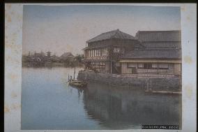
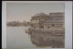
Yaomatsu Restaurant, Mukojima

Yaomatsu Restaurant, Mukojima

Yaomatsu-ro Restaurant seen from Makura Bridge at confluence of the Gennomori and Sumida rivers. The restaurant was opened in April 1870 as a branch of Yaomatsu located at Suijin-no-Mori. Customers drank sake while enjoying the view of boats crossing the Sumida River and Sensoji Temple across the river, and Yaomatsu-ro gained popularity as an early waterfront restaurant. Taken between 1887 and 1897. Same as photograph #2104.==Date:unknown, Place:Tokyo, Photo:unknown, (Credit:Nagasaki University Library/Kyodo News Images) [Cabinet Number93‐14‐0]

  •  
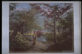
Autumn tints of Takinogawa, Oji

Autumn tints of Takinogawa, Oji

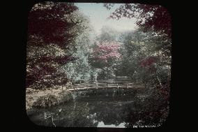
This seems to be Otonashi River (Shakujii River near Kongoji, the autumn colours temple. A bridge with a romantic atmosphere is said to have spanned a bend in the river. There was a bridge with a pleasant atmosphere. The deity Benzaiten was enshrined in a hollow in the rock near the bridge. A teahouse once stood on the hill. The river merges into Sumida River (formerly Arakawa), which flows northeast. Taken in the mid-Meiji Period.==Date:unknown, Place:Tokyo, Photo:unknown, (Credit:Nagasaki University Library/Kyodo News Images) [Cabinet Number88‐35‐0]

  •  
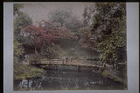
Autumn tints of Takinogawa, Oji

Autumn tints of Takinogawa, Oji

This bridge appears many times in photographs of Takinogawa taken during the Meiji Period. The former Takinogawa Village was located west of Mt. Asuka. The groves of maple trees where people enjoyed the autumn colours centered around Kongoji, which was also called the autumn colours temple (present-day Takinogawa 3-chome, Kita Ward). People enjoyed the cherry blossoms at Mt. Asuka in spring and the colourful leaves of Takinogawa in autumn. Mid-Meiji Period.==Date:unknown, Place:Tokyo, Photo:unknown, (Credit:Nagasaki University Library/Kyodo News Images) [Cabinet Number85‐13‐0]

  •  
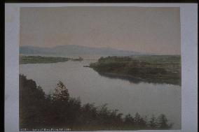
Lake Biwa seen from Ishiyama

Lake Biwa seen from Ishiyama

View of Seta River from Tsukimi-tei at Ishiyamadera Temple, with Lake Biwa and the Hira Mountain Range in the distance. The bridge in the centre is Seta-no-Karahashi, formerly the only bridge spanning Seta River and an important transportation route in ancient times. At present there are many bridges over the river.==Date:unknown, Place:Shiga, Photo:Tamamura Kozaburo, (Credit:Nagasaki University Library/Kyodo News Images) [Cabinet Number79‐14‐0]

  •  
Tonosawa

Tonosawa

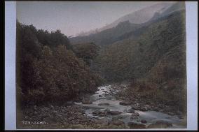
This is a little higher up from the present iron bridge of Deyama. The Hayakawa River flows in the center. The gradient is milder around here, and so is the flow. The mountain on the right is the foot of Tonomine and a part of Mt. Myougadake is visible behind. There is Amida Temple in Tonomine. The forest on the left is at the foot of Mt. Yusaka, and at present National Route 1 runs along Hayakawa River.==Date:unknown, Place:Hakone, Photo:R. Stillfried, (Credit:Nagasaki University Library/Kyodo News Images) [Cabinet Number77‐15‐0]

  •  
Furumachi-bashi Bridge over Nakashima River and Koeiji Temple

Furumachi-bashi Bridge over Nakashima River and Koeiji Temple

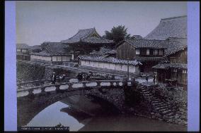
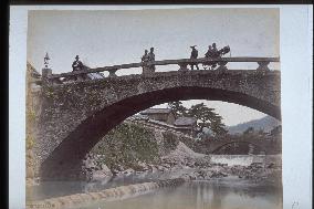
Furumachi-bashi Bridge over Nakashima River and Koeiji Temple==Date:unknown, Place:Nagasaki, Photo:unknown, (Credit:Nagasaki University Library/Kyodo News Images)

  •  
Nunobiki Falls

Nunobiki Falls

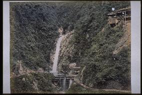
Medaki waterfall at Nunobiki Falls, taken around the same time as photograph #2271 (Shinkoji Temple), #4092 (Mt. Suwa), and #4094 (Arima Spa) in the mid-Meiji Period. Visitors normally took the path on the right side of the river and then proceeded along the road to the left to Medaki waterfall. After that, they crossed a wooden bridge and negotiated the winding mountain path to Odaki waterfall.==Date:unknown, Place:Kobe, Photo:Tamamura Kozaburo, (Credit:Nagasaki University Library/Kyodo News Images) [Cabinet Number68‐4‐2]

  •  
Sokokura Spa

Sokokura Spa

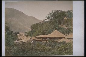
This is the Sokokura Spa viewed from the opposite side of Jakotsu River, after crossing Mannen Bridge. The hip roof on the left is Jizodo (a temple hall where a Buddhist deity is enshrined). The house with a thatched roof before it is Yorozuya , Umeya is in front of that. The two-storied building on the right is Tsutaya. The house partially visible on the right is Sengokuya Inn. The roofs of these spa houses are thatched. Therefore, this photo was taken before the big fire of 1881.==Date:unknown, Place:Hakone, Photo:Usui Shuzaburo?, (Credit:Nagasaki University Library/Kyodo News Images) [Cabinet Number65‐16‐0]

  •  
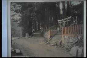
The approach to Toshogu Shrine,Nikko

The approach to Toshogu Shrine,Nikko

This is the entrance to the Sannai area encompassing Nikko Toshogu Shrine and Sanrinoji Temple. Shinkyo Bridge and Nikko Bridge are located to the left. Daiya River is visible in the background to the left. Nagasaka Slope is in the centre. The shrine on the right is Jinjaodo. Stones cut for construction are visible on the left.==Date:unknown, Place:Nikko, Photo:unknown, (Credit:Nagasaki University Library/Kyodo News Images) [Cabinet Number54‐6‐0]

  •  
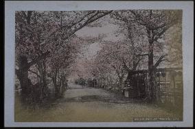
Cherry trees at Mukojima

Cherry trees at Mukojima

The area across Sumida River from Asakusa is Mukojima. There is no official boundary, but area from Mokuboji Temple to Makura Bridge is referred to as Mukojima. The banks of Sumida River at Mukojima are called Sumida-tei or Boku-tei. Cherry trees were planted here during the Kyoho Period (1716-36) by the 8th Shogun Tokugawa Yoshimune, and saplings were planted from time to time thereafter. This area thus became the most popular place to enjoy cherry blossoms in Edo. Taken around 1898.==Date:unknown, Place:Tokyo, Photo:unknown, (Credit:Nagasaki University Library/Kyodo News Images) [Cabinet Number53‐40‐0]

  •  
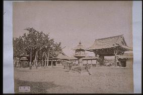
Nishi Honganji Temple

Nishi Honganji Temple

The grounds of Nishi Honganji Temple, looking from the southeastern side of the Goei-do facing northeast. The gate of the Goei-do and a mizubuki gingko tree are depicted on the right and left. A man is leaning against the bronze lantern in the centre. Other people are also present on the temple grounds. The Goei-do is in irimoya style with roof tiles and was built in 1645. The rails of a bridge over Horikawa River are visible beyond the Goei-do gate.==Date:unknown, Place:Kyoto, Photo:unknown, (Credit:Nagasaki University Library/Kyodo News Images) [Cabinet Number52‐28‐0]

  •  
Yaomatsu Restaurant, Mukojima

Yaomatsu Restaurant, Mukojima

Yaomatsu Restaurant on the right was opened in a refurbished boat shed formerly owned by the Tokugawa family of Mito. The water in front is probably Gennomori River, seen from Makura Bridge. There was a ferry stop at the end of the bridge called Yamanoshuku-no-Watashi (Makurabashi-no-Watashi) for passage to Asakusa on the other side of the river. The five-story pagoda Kan'non-do Hall and the Nio Gate of Sensoji Temple are visible. The Ryounkaku built in 1890 is visible to the left of the pagoda, indicating that the photograph was taken after that year.==Date:unknown, Place:Tokyo, Photo:unknown, (Credit:Nagasaki University Library/Kyodo News Images) [Cabinet Number47‐7‐0]

  •  
Rickshaw in front of a great gate

Rickshaw in front of a great gate

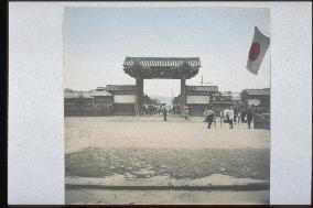
The Somon Gate of Nishihonganji Temple is seen from the Miei-do Gate. The bustling front street stretches away behind the gate. The railing of the bridge over the Horikawa River is visible on the right. A national flag is flying at the Miei- Gate, above the bridge. Three rickshaw men are waiting for customers in front of the gate. The Higashiyama mountains are visible in the far back.==Date:unknown, Place:Kyoto, Photo:unknown, (Credit:Nagasaki University Library/Kyodo News Images) [Cabinet Number46‐113‐0]

  •  
Autumn tints of Takinogawa, Oji

Autumn tints of Takinogawa, Oji

The red leaves of Takino River. Visitors climbing along the river arrive at a place called the red leaves temple or Kongoji of Takino River.==Date:unknown, Place:Tokyo, Photo:Tamamura Kozaburo, (Credit:Nagasaki University Library/Kyodo News Images) [Cabinet Number31‐78‐0]

  •  
Shinkyo Bridge,the Daiyagawa River

Shinkyo Bridge,the Daiyagawa River

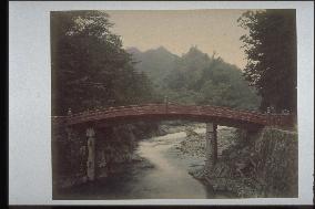
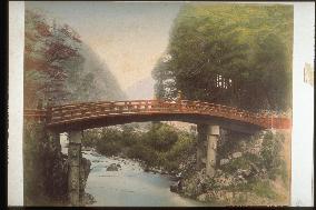
The red-painted Shinkyo Bridge built over Daiya River is located at the entrance of Nikko Shaji. The Shinkyo Bridge lost in the flood of 1901 had joints in the bridge girders, as seen in the photo.The present Shinkyo Bridge has no girders. There are no electric poles on the side of Rinoji Temple to the right. The carapace stone next to the bridge girder located upstream from Shinkyo Bridge was lost in the flood of 1901.==Date:Before 35th year of Meiji, Place:Nikko, Photo:unknown, (Credit:Nagasaki University Library/Kyodo News Images) [Cabinet Number11‐8‐0]

  •  
Bridge of nakashimagawa river

Bridge of nakashimagawa river

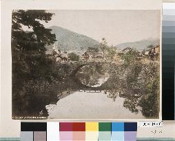
The Ichiran Bridge (to the fore) and Furumachi Bridge (in the rear) spanning Nakashima River. A lamp stands on the bridge, and rickshaws,and men wearing silk hats are seen in the photo. The temple to the left is Koeiji. Two of the many stone bridges over the Nakashima River are photographed.==Date:Middle Meiji, Place:Nagasaki, Photo:Ogawa Kazumasa, (Credit:Nagasaki University Library/Kyodo News Images) [Cabinet Number9‐40‐0]

  •  
Shinkyo Bridge,the Daiyagawa River

Shinkyo Bridge,the Daiyagawa River

The red painted Shinkyo Bridge build over River Daiya is located at the entrance of Nikko Shaji. There were joints, as seen to the left, on the bridge girders of Kami Bridge before it was destroyed in the floods of 1902. The present Kami Bridge has no joints. There are no electric cables in the photo on the side of Rinoji Temple to the right.==Date:Before 35th year of Meiji, Place:Nikko, Photo:Ogawa Kazumasa, (Credit:Nagasaki University Library/Kyodo News Images) [Cabinet Number7‐4‐0]

  •  
Downstream area of Oura River

Downstream area of Oura River

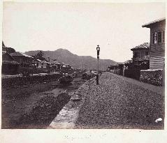
This photo is taken halfway up the Oura River looking downstream. The street light was particular to the foreign settlement. The bridge downstream is Benten Bridge and the mountain on the other side of Nagasaki Port is Mt. Inasa. A boat called ‘sanpan’, used to fetch goods from the ships offshore, is moored. The area, ‘Sagarimatsu’, was named after the pine tree on the left. The roof of Myogyoji Temple is barely discernable. The Sagarimatsu area was the foreign settlement’s town center with a bar for foreigners, a restaurant, an inexpensive international hotel, and a shop selling goods for foreigners and until around 1900, the place for locals to socialize.==Date:about 1874, Place:Nagasaki, Photo:Ueno Hikoma?, (Credit:Nagasaki University Library/Kyodo News Images)

  •  
Nakashima River and Amigasa-bashi Bridge

Nakashima River and Amigasa-bashi Bridge

Amigasa Bridge over Nakashima River. This is an arch-style stone bridge connecting Hakata-machi with Motokamiya-machi. It was destroyed by the great flood of Nagasaki in 1982 and replaced with a new bridge with steep stairs. Suwa Shinto Shrine is visible beside the large pine tree on the left. The temple gate at the foot of the bridge is that of Taiheiji Temple (now in Naminohira-machi) constructed in 1766.==Date:unknown, Place:Nagasaki, Photo:unknown, (Credit:Nagasaki University Library/Kyodo News Images) [Cabinet Number109‐19‐0]

  •  
The Oura foreign settlement and Nagasaki Harbour seen from Don-no-Yama

The Oura foreign settlement and Nagasaki Harbour seen from Don-no-Yama

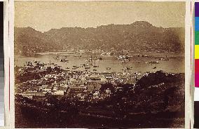
This photo captures the area around the Oura River as viewed from mid-hill Mt. Donnoyama. At the mouth of the river stands Sagarimatsu Bridge, built in 1869 for the horse trail in the settlement. A bit upstream stands Benten Bridge built during the Bunkyu period (1861-1864) when the land was reclaimed for the Oura settlement. The U-shaped building visible next to Myogyoji Temple on the left hill is the Belle Vue Hotel. On the other side of the port is the Nagasaki Shipyard controlled by the Ministry of Engineering. Since the dormitory for foreign employees built in April 1874, doesn’t show in this photo, it must have been taken before then.==Date:1872, Place:Nagasaki, Photo:Ueno Hikoma, (Credit:Nagasaki University Library/Kyodo News Images)

  •  
Viewing the Old Site of Nishi-Yakusho from the Old Site of Daitokuji Temple

Viewing the Old Site of Nishi-Yakusho from the Old Site of Daitokuji Temple

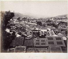
This photo captures the old site of the Nishi-Yakusho of the former Nagasaki Bugyosho office (present-day Prefectural Office) over the Zenza river taken from the old site of Daitokuji Temple. What used to be the Nishi-Yakusho is now a vacant lot. The first Prefectural Office made of wood was built in July 1874. However, the building was destroyed soon by a typhoon on August 20 of the same year. Therefore, it is presumed that this photo was probably taken around 1873 before the construction of the first Prefectural Office building. The big white building on the left is the site of the present-day main office of Eighteen Bank. The area with foliage in the center is where the old Satsuma Domain residence used to be, but the main building is gone. We can see Shinchi Bridge over the Doza river at Ishibashi, where the front gate of Shinchi-Kurasho (warehouse) was. ==Date:about 1874, Place:Nagasaki, Photo:Ueno Hikoma?, (Credit:Nagasaki University Library/Kyodo News Images)

  • Main
  • Top
  • Editorial
  • Creative
  • About Us
  • About ILG
  • Terms of use
  • Company
  • BEHIND
  • Price List
  • Single Plan
  • Monthly Plan
  • Services
  • Shooting
  • Rights Clearance
  • Support
  • FAQ
  • How To Buy
  • Contact Us
  • Become a Partner

© KYODO NEWS IMAGES INC

All Rights Reserved.

  • Editorial
  • Olympics
  • News
  • Sports
  • Japan
  • Tech
  • Royal
  • Disaster
  • NorthKorea
  • Old Japan
  • SNS
  • Creative
  • Food
  • Japan
  • Landscape
  • Animal
  • Popular
  • #Ukraine
  • #Russia
  • #coronavirus
  • #N. Korea
  • #Thailand
  • #China
  • #Ukraine
  • #Russia
  • #coronavirus
  • #N. Korea
  • #Thailand
  • #China
  • Food
  • Japan
  • Landscape
  • Animal
  • Olympics
  • News
  • Sports
  • Japan
  • Tech
  • Royal
  • Disaster
  • NorthKorea
  • Old Japan
  • SNS