•  

Storm Kathleen Brings Strong Winds, High Waves To Ireland, UK Coasts 2

Storm Kathleen brought strong winds to Ireland, Northern Ireland, Scotland and parts of western England on Saturday, April 6. Videos posted on social media show big waves hitting the coasts across the regions.

  •  
The city of Nagasaki and Nagasaki Harbour

The city of Nagasaki and Nagasaki Harbour

Many buildings were built on the Umegasaki landfill area on the left. The Nagasaki Custom House is also visible dockside. Western-style buildings have been built by the Shinchi sea side and an embankment is in the process of being built behind the buildings. Shin-Ohashi Bridge, constructed in 1869 at the mouth of Nakashima River before redirection work, is visible. A new western-style building is constructed on Dejima across from Tsukimachi. However, neither Mii Church built in 1876 nor the bell tower of Seikokai Theology School built in 1878 is visible. Therefore, this photo must have been taken around 1872. This is a bird's-eye view from Mt. Kazagashira of a typical view of Nagasaki around the beginning of the Meiji period.==Date:1873, Place:Nagasaki, Photo:Uchida Kuichi, (Credit:Nagasaki University Library/Kyodo News Images)

  •  
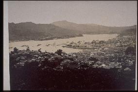
The north part of the central district,Nagasaki

The north part of the central district,Nagasaki

The camera is pointing from Mt. Kazagashira to the northern part of Nagasaki city. The harbour is seen beyond Dejima and Umegasaki. The opposite bank is Akunoura. Dejima Bridge is seen. This is a similar camera angle as the photos numbered 75-9 and 75-22.==Date:unknown, Place:Nagasaki, Photo:unknown, (Credit:Nagasaki University Library/Kyodo News Images) [Cabinet Number21‐10‐0]

  •  
Dejima and Nagasaki harbour seen from Don-no-Yama

Dejima and Nagasaki harbour seen from Don-no-Yama

In the centre is Dejima, and to the fore are the Shinchi warehouses and the settlements of Umegasaki. The shore line of Dejima can be seen clearly. A wooden bridge (Umegasaki Bridge) can be seen connecting Shinchi and the settlements.==Date:unknown, Place:Nagasaki, Photo:Ueno Hikoma, (Credit:Nagasaki University Library/Kyodo News Images) [Cabinet Number21‐2‐0]

  •  
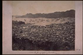
Center of NAGASAKI downtown and umegasaki settlement

Center of NAGASAKI downtown and umegasaki settlement

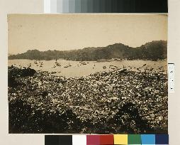
Written March 1866 by Beato. A wide view of the central part of Nagasaki and Dejima, Shinchi and Umegasaki from Mt.Kazagashira. There is no bridge at the mouth of Nakashima river, and the building of the Nishiyakusho is seen to the upper right. Shinchi is still skirtde on the rea by sea. There are many foreign ships in the harbour.==Date:1866, Place:Nagasaki, Photo:F. Beato, (Credit:Nagasaki University Library/Kyodo News Images) [Cabinet Number17‐2‐0]

  •  
A panoramic view of Nagasaki Harbour

A panoramic view of Nagasaki Harbour

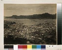
A bird's eye view of the north part of the city from Kazagashira. Nakashima River was later diverted to the back of Dejima and now has a bridge built over it. The customs building is seen on the sea.The caption reads Nagasaki Harbour in English at the left corner. The photo was taken from the same angle as the photo numbered 21-10.==Date:unknown, Place:Nagasaki, Photo:Tamamura Kozaburo, (Credit:Nagasaki University Library/Kyodo News Images) [Cabinet Number11‐45‐0]

  •  
View of dejima,fan-shaped artificial island,from kannai

View of dejima,fan-shaped artificial island,from kannai

View of Dejima and Nagasaki Harbour from the Chinese Quarter in Kannai near the Shinchi warehouses. The bridge in the centre is Umegasaki Bridge. The inlet is the present Minato Park. At the seaside of Dejima is a protruding Umamawashi built in 1867.==Date:unknown, Place:Nagasaki, Photo:Kusakabe Kinbei, (Credit:Nagasaki University Library/Kyodo News Images) [Cabinet Number2‐1‐0]

  •  
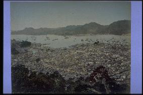
The city of Nagasaki and Nagasaki Harbour

The city of Nagasaki and Nagasaki Harbour

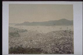
This is a view from Mt. Kazagashira looking over the city centre and harbour. Land reclamation has progressed in the Shinchi area, and new buildings are being erected. But the old stone embankments still remain. Dejima Island and Dejima Bridge are visible along with Shin-Ohashi Bridge (built in 1869) and a white Western-style residence in Tsuki-machi. The date is 1871or 1872. War vessels and ships are anchored in the Nagasaki Harbour, and the Akunoura shipyard and Inasa area are visible on the opposite shore.==Date:1873, Place:Nagasaki, Photo:Uchida Kuichi , (Credit:Nagasaki University Library/Kyodo News Images) [Cabinet Number114‐31‐0]

  •  
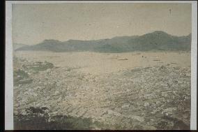
The city of Nagasaki and Nagasaki Harbour

The city of Nagasaki and Nagasaki Harbour

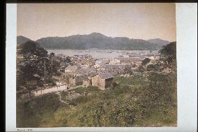
This is a view from Mt. Kazagashira looking over Nagasaki Harbour toward the Akunoura area. The hill with many trees on the left is Higashiyamate, while Dejima Island is seen to the right of centre. Shin-Ohashi Bridge built in 1869 is seen at the mouth of Nakashima River. The photograph portrays the tiled rooftops of Nagasaki reinforced with white plaster around 1880.==Date:unknown, Place:Nagasaki, Photo:unknown, (Credit:Nagasaki University Library/Kyodo News Images) [Cabinet Number114‐16‐0]

  •  
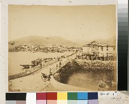
Viewing Shin-Ohashi from Umegasaki Bridge

Viewing Shin-Ohashi from Umegasaki Bridge

This is a view of Shinchi and Dejima from Umegasaki Bridge looking along the waterfront toward Dejima and Shinchi. Umegasaki Bridge is the wooden structure built in 1869. The date is between 1877 and 1887.==Date:unknown, Place:Nagasaki, Photo:unknown, (Credit:Nagasaki University Library/Kyodo News Images) [Cabinet Number110‐47‐0]

  •  
Panoramic view of Nagasaki Harbour from across the shore

Panoramic view of Nagasaki Harbour from across the shore

This is a three-panel panoramic photograph depicting Ohato, Shinchi, the Oura waterfront, Matsugae Bridge, Minamiyamate, Kozone, Naminohira and Furukawa-machi. Shin-Ohashi, Umegasaki and Matsugae bridges have been built as part of the re-routing of Nakashima River, indicating that the date is around 1887. The left panel captures the entire view of Dejima, Shin-ohashi Bridge, Shinchi and Umegasaki, the centre panel the area from Umegasaki to Minamiyamate, the Russian Consulate and the central part of the foreign settlement, and the right panel the area from the central part of the foreign settlement to Furukawa-machi. The southern end of the Minamiyamate neighbourhood area is visible.==Date:unknown, Place:Nagasaki, Photo:unknown, (Credit:Nagasaki University Library/Kyodo News Images) [Cabinet Number107‐1‐0]

  •  
Panoramic view of Nagasaki Harbour from across the shore

Panoramic view of Nagasaki Harbour from across the shore

This is a three-panel panoramic photograph depicting Ohato, Shinchi, the Oura waterfront, Matsugae Bridge, Minamiyamate, Kozone, Naminohira and Furukawa-machi. Shin-Ohashi, Umegasaki and Matsugae bridges have been built as part of the re-routing of Nakashima River, indicating that the date is around 1887. The left panel captures the entire view of Dejima, Shin-ohashi Bridge, Shinchi and Umegasaki, the centre panel the area from Umegasaki to Minamiyamate, the Russian Consulate and the central part of the foreign settlement, and the right panel the area from the central part of the foreign settlement to Furukawa-machi. The southern end of the Minamiyamate neighbourhood area is visible.==Date:unknown, Place:Nagasaki, Photo:unknown, (Credit:Nagasaki University Library/Kyodo News Images) [Cabinet Number107‐1‐0]

  •  
Panoramic view of Nagasaki Harbour from across the shore

Panoramic view of Nagasaki Harbour from across the shore

This is a three-panel panoramic photograph depicting Ohato, Shinchi, the Oura waterfront, Matsugae Bridge, Minamiyamate, Kozone, Naminohira and Furukawa-machi. Shin-Ohashi, Umegasaki and Matsugae bridges have been built as part of the re-routing of Nakashima River, indicating that the date is around 1887. The left panel captures the entire view of Dejima, Shin-ohashi Bridge, Shinchi and Umegasaki, the centre panel the area from Umegasaki to Minamiyamate, the Russian Consulate and the central part of the foreign settlement, and the right panel the area from the central part of the foreign settlement to Furukawa-machi. The southern end of the Minamiyamate neighbourhood area is visible.==Date:unknown, Place:Nagasaki, Photo:unknown, (Credit:Nagasaki University Library/Kyodo News Images) [Cabinet Number107‐1‐0]

  • Main
  • Top
  • Editorial
  • Creative
  • About Us
  • About ILG
  • Terms of use
  • Company
  • BEHIND
  • Price List
  • Single Plan
  • Monthly Plan
  • Services
  • Shooting
  • Rights Clearance
  • Support
  • FAQ
  • How To Buy
  • Contact Us
  • Become a Partner

© KYODO NEWS IMAGES INC

All Rights Reserved.

  • Editorial
  • Olympics
  • News
  • Sports
  • Japan
  • Tech
  • Royal
  • Disaster
  • NorthKorea
  • Old Japan
  • SNS
  • Creative
  • Food
  • Japan
  • Landscape
  • Animal
  • Popular
  • #Ukraine
  • #China
  • #coronavirus
  • #N. Korea
  • #Russia
  • #Thailand
  • #Ukraine
  • #China
  • #coronavirus
  • #N. Korea
  • #Russia
  • #Thailand
  • Food
  • Japan
  • Landscape
  • Animal
  • Olympics
  • News
  • Sports
  • Japan
  • Tech
  • Royal
  • Disaster
  • NorthKorea
  • Old Japan
  • SNS